


Spring Creek Twp. Voting District, Becker County, Minnesota
About
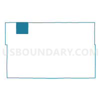
Outline

Summary
| Unique Area Identifier | 601112 |
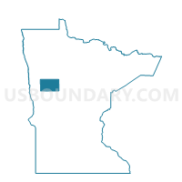
| Name | Spring Creek Twp. Voting District |
| County | Becker County |
| State | Minnesota |
| Area (square miles) | 37.76 |
| Land Area (square miles) | 37.20 |
| Water Area (square miles) | 0.56 |
| % of Land Area | 98.53 |
| % of Water Area | 1.47 |
| Latitude of the Internal Point | 47.09464560 |
| Longtitude of the Internal Point | -96.01689670 |
Maps

Graphs
Select a template below for downloading or customizing gragh for Spring Creek Twp. Voting District, Becker County, Minnesota


Neighbors
Neighoring Voting District (by Name) Neighboring Voting District on the Map
- Atlanta Twp. Voting District, Becker County, MN
- Callaway Twp. Voting District, Becker County, MN
- Flom Twp. Voting District, Norman County, MN
- Lake Grove Twp. Voting District, Mahnomen County, MN
- Ogema Voting District, Becker County, MN
- Popple Grove Twp. Voting District, Mahnomen County, MN
- Riceville Twp. Voting District, Becker County, MN
- Walworth Twp. Voting District, Becker County, MN
- White Earth Twp. Voting District, Becker County, MN
Top 10 Neighboring County Subdivision (by Population) Neighboring County Subdivision on the Map
- White Earth township, Becker County, MN (828)
- Callaway township, Becker County, MN (287)
- Flom township, Norman County, MN (218)
- Lake Grove township, Mahnomen County, MN (189)
- Ogema city, Becker County, MN (184)
- Popple Grove township, Mahnomen County, MN (139)
- Atlanta township, Becker County, MN (119)
- Spring Creek township, Becker County, MN (114)
- Walworth township, Becker County, MN (87)
- Riceville township, Becker County, MN (83)
Top 10 Neighboring Place (by Population) Neighboring Place on the Map
Top 10 Neighboring Unified School District (by Population) Neighboring Unified School District on the Map
Top 10 Neighboring State Legislative District Lower Chamber (by Population) Neighboring State Legislative District Lower Chamber on the Map
Top 10 Neighboring State Legislative District Upper Chamber (by Population) Neighboring State Legislative District Upper Chamber on the Map
Top 10 Neighboring 111th Congressional District (by Population) Neighboring 111th Congressional District on the Map
Top 10 Neighboring Census Tract (by Population) Neighboring Census Tract on the Map
- Census Tract 9400, Becker County, MN (3,833)
- Census Tract 4509, Becker County, MN (3,094)
- Census Tract 9401, Mahnomen County, MN (2,946)
- Census Tract 9601, Norman County, MN (2,760)